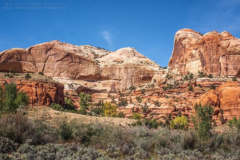
From Bryce my travels had me following UT-12. A fun and scenic highway as it drops into the Escalante Canyon area. With what seems to be unlimited canyons and slots to explore. I was headed for the Calf Creek Campground within the Grand Staircase / Escalante National Monument.
With only fourteen campsites I hoped to be able to secure one as it would be midday when I arrived. As I pulled into the campground I was greeted by the Camp Hostess whom I immediately asked about vacancies. She had no idea but said her husband was just up the road tending to his chores on the grounds. I met him at the third site in and asked if the site was available. He responded that it indeed was and he would be out of my way as soon as he was done cleaning the fire pit.
I proceeded to pick his brain for information on the area, in particular hiking the Escalante River and the trail up to Lower Calf Creek Falls. He told me that he was not sure about the Escalante. Apparently it was impassable a couple of days prior due to the same recent storms that I had encountered across northern Arizona. Carlin had told me to wear water shoes and plan on multiple crossings, so I figured the river must have been running very high. He also told me that the Lower Calf Creek Falls trailhead was just up the road within the campground and that it was about a 6 mile round trip hike. I was also interested in whether he knew anything about some of the local slot canyons and if I could reach any non-technical ones in my Tiguan. He told me that the only ones he knew of were down the “Hole in the Rock Road”, but that the road had been washed out and was closed a ways down before getting to the slots. He did say he was pretty sure I could get as far down as Devils Garden though.
Well there it was, I had a plan. Check out and hike the Escalante after setting up camp, hike up to Lower Calf Creek Falls in the morning and try to go down the “Hole in the Rock Road” to Devils Garden after that.
After setting up camp, I headed back to the Escalante River trailhead where I changed into my Keen river shoes. At the trailhead I found a self register, where you sign in stating where you are heading and how long you plan to be out, just in case you don’t come back they know where to go looking for you. It also had a comments section which I read and two days prior a group commented “Just kidding, river is too scary!”. I thought…this could be interesting!
A couple of hundred yards down the trail I came to the first crossing. There was a good amount of water flowing but it was not very wide. I found a broken branch that someone had left and decided to use it for balance. I probed the edge to get an idea of how deep it was as the water was too muddy to see into. It didn’t seem too deep so I rolled up my pant legs and heart pounding and adrenaline rushing headed into the rushing water. The first crossing reached about knee level as I tried to stay on what appeared to be submerged rocks. Reaching the other side, I kindly left the branch for any returning hiker that may need it.
I had no idea how many times I would be crossing the Escalante, but at the second crossing I search for a permanent wading staff for the day and was glad I did. Several of the crossings had “sink holes” (like quicksand) in the river, usually near the edges of the river, that threatened to suck the shoes right off my feet. Using care I slowly pulled my feet out of the seemingly bottomless sucking sand. I later found out that Carlin and family had backpacked this same stretch of river and that she had lost a shoe in one of these “sink holes”. There was a total of eight crossings before I was back at the trailhead.
After three crossings, without any idea what I would find, I decided to explore off trail back towards some cliffs, alcoves and a canyon. When returning from this side trip, looking across and up the Escalante Canyon, I viewed what looked to be an arch on the canyon wall. This must be the Natural Bridge I had read about. So back to the trail, across the river, through the woods to Grandma’s…oh, sorry got carried away there. Sure enough it was the Escalante Natural Bridge. After poking around a bit and photographing the wonder, I headed back towards the trailhead, hanging on firmly to my trusty wading staff.
It was truly a different kind of adventure hike than I had ever done before and I look forward to coming back as I hear there are some petroglyphs to be found if you hike the river the opposite direction.


Very different rock formations than Bryce, but also interesting. Hope you have a water tight bag for camera gear when making river crossings.
Unfortunately all my dry bags were in storage in Denver, I didn’t anticipate crossing any rivers. Fortunate to not have had any mishaps!