
Said goodbye to the Hole In The Rock Road area and set out to move camp off the Burr Trail somewhere. I will be back, there is still much to do in this area in the future sometime.
On my way out I backtracked a few miles back to Escalante. I needed to fuel up and pickup the usual supplies. As quaint as it was to be time warped back to “Mayberry” at Nelsons Station, I decided I did not want to spend that much time in town, and picked the only other filling station in town.
I proceeded northeast on UT12 passing the Escalnte River and Calf Creek areas that I had explored the previous fall. On into the tiny town of Boulder, turning on the Burr Trail Road.
The Burr Trail is a 68-mile backcountry route extending from the town of Boulder, through Grand Staircase-Escalante National Monument into Capital Reef National Park and then south on to the town of Bullfrog in Glen Canyon National Recreation Area. The Burr Trail is named after John Burr, who developed this trail to move cattle to wintering grounds back in 1876.
I reached my farthest point from last fall on the Burr Trail with the clouds continually building. About a mile past this point was the Wolverine Loop Road. My intentions were to proceed down the Wolverine, locate a camp and hike Wolverine Canyon in the next couple of days. Reports, according to Andrea, were that a storm was moving in that would continue for the next two days.
Hesitantly, I turned on the Wolverine Loop, but quickly decided that this would definitely be the kind of road you would get stuck on in wet muddy conditions. Therefore, I turned around and found a spot off the Burr Trail that I felt would not be a problem to escape from if conditions got bad.
The storm finally hit at 11:00 AM, and quickly turned to white out conditions. At around 1:00 PM, I began to hear what sounded like heavy machinery. Through the snow, I could see something moving up and down the road on the big cliff on the Burr Trail Rood.
When the snow subsided a bit, I got out my telephoto lens and could see they were clearing a landslide. Good thing I had no plans of going anywhere anytime soon!
Sitting around in the car during the whiteout, I listened to music and tried to charge batteries. That is until I blew a fuse. After blowing two, I finally located the the problem. One of the power inverters had developed a short caused by some wiring that had broke. So I swapped fuses around until I found one that would not disable the car or make it dangerous to drive. I would have to go without the parking brake for the balance of the trip. But down to just one power inverter would make keeping up with the charging all that more difficult.
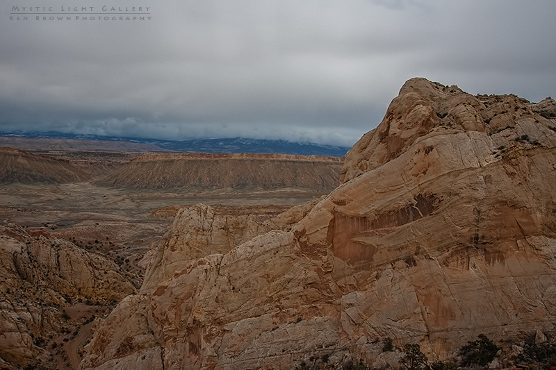
Later in the afternoon, when the whiteout subsided, I took the drive down the Burr Trail to the Waterpocket Fold in Captal Reef National Park. The views of the Strike Valley from the cliffs along The Fold were just amazing and dramatic with the low hanging storm clouds.
Upon arriving at the intersection of the Burr Trail heading south to Bullfrog and the dirt track headed further north into Capital Reef, I decided that I wanted to drive this section on my way out. It would be a journey of 40 miles north to its intersection with UT24, following the Waterpocket Fold the entire way. Now that would be interesting!
Tomorrow I will have to decide whether the Wolverine Loop is passable, or if it is better to just stay put for another day and let things dry out…


