You should probably get comfortable for this one, it reads like a short novel! This is a trip I had on my Bucket List for many years… At least as long as I had been adventuring into slot canyons. And in some grim way, the idea of exploring it was heightened by the story of Aron Ralston. This is Bluejohn Canyon… A complex of slot canyons in a very remote location of South Eastern Utah. Bluejohn Canyon was made famous by the epic story of Aron Ralston, who in 2003 had the unfortunate incident of getting his arm caught under a boulder that dislodged as he climbed over it… All alone, he was trapped there for 127 hours until he amputated his arm with a dull pocket knife. The story was brought to the public by his book Between A Rock And A Hard Place and the movie 127 Hours.
Even with all my experience exploring slot canyons, this would be the first Technical Slot Canyon that I had done. And only then made possible by inviting my son Taylor, who through his mountaineering experience, brought the knowledge of setting up the belays and rappels. The itinerary was ambitious at best and probably bit off more than I could chew right from the start… I had researched the canyon complex for weeks prior, and came up with a plan to do a loop that would be a minimum of 10.8 miles. Stretching that out to over 14 miles if we felt we had the strength to venture into the Lower Bluejohn Canyon where Aron had been trapped. This part of the canyon is considered by some to be the most beautiful part of the canyon with its convoluted sculpturing, rivaling that of Antelope Canyon in Arizona.
I had been considering getting a new GPS device for an upcoming trip in May, when I came across some information about a good GPS navigation application that I could install on my phone. I decided to take the plunge and test it out on the trip to Bluejohn. So I took the time to set waypoints of all the major locations along our intended route. This would later come to be a very wise choice!
We set out on Friday with Taylor and Harmony picking me up from work at 3:30 PM… It would be a minimum 5 hour drive south into the desert to the base camp location at Granary Spring. We finally arrived sometime after 9:00 PM, set up the tent in the dark and enjoyed some cold refreshments as Taylor captured the amazingly starry night with his camera. With the alarm set for 5:30 AM, we tried to drift off to sleep while a nearby group of youthful canyoneers howled at the moon and free form rapped around their campfire…
The alarm came all too quickly and I arose from warmth of my down sleeping bag in the tent to begin heating water on my new MSR Pocket Rocket stove for coffee and oatmeal. Harmony and Taylor soon followed as the first hot brews were ready… We were up early for our pre-dawn start because it would be a very long day. By the shortest route it would be almost 11 miles, and negotiating your way through slot canyons can be a very slow process. We loaded up our packs with more food than we would probably need, each carrying 3 litres of water and a frozen Gatorade, camera and climbing gear, first aid kit and a minimum of extra clothing…
With barely enough light to see we were off hiking through the desert, headlamps donned as the pastel sunrise colors painted the clouds… The clouds… Hmmmmm… I had failed to mention to Harmony and Taylor that the forecast had shown a 20% chance of precipitation. Figuring that was a pretty slim chance, there was no need to even bring it up…
We made our way down the upper reaches of the Main Fork of Bluejohn wash, where we were to finish the hike, through The Gateway of two low hills and out across the open flats towards the East Fork of Bluejohn Canyon. The GPS waypoints were turning out to be spot on and we reached East Bluejohn Canyon proper after 2 miles of hiking.
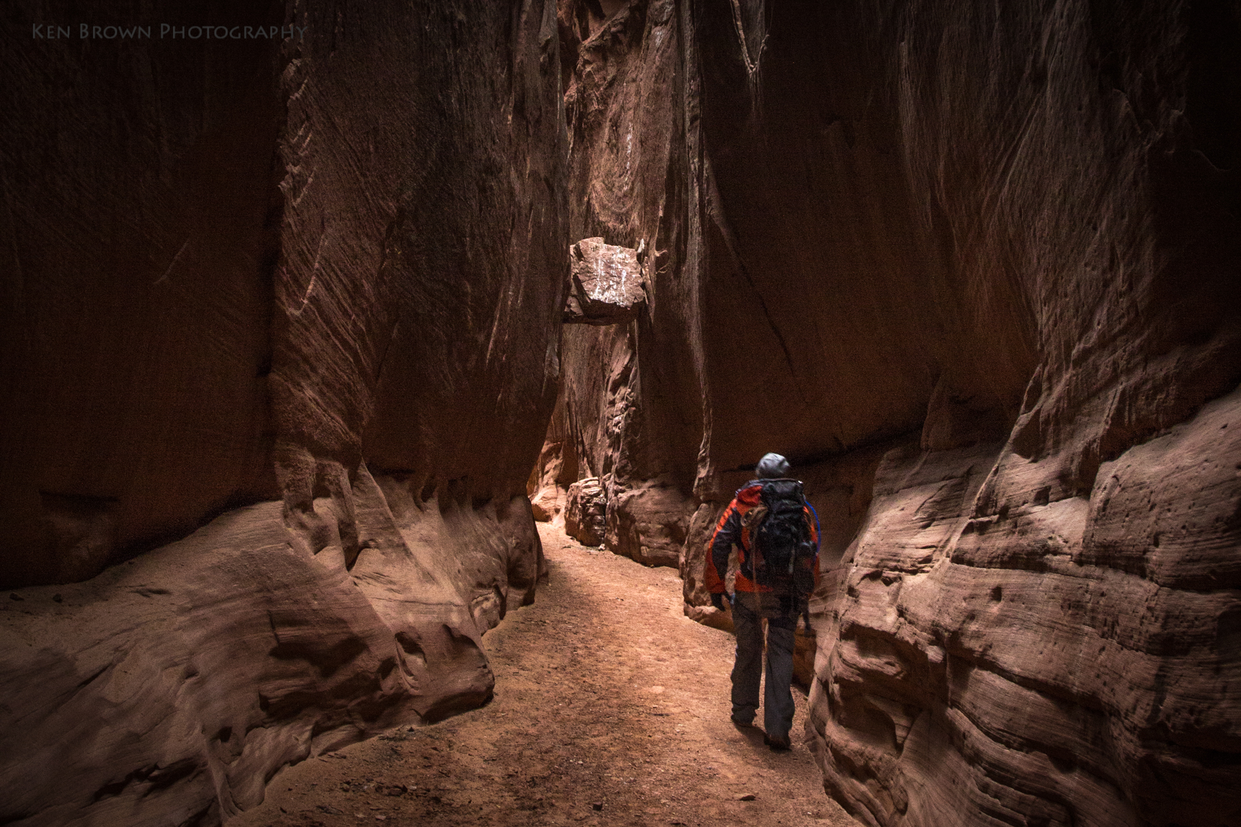
Here the technical difficulties begin with a 50 foot rappel into the slot. Taylor set up the rap over an old dried up log that had been placed by other canyoneers previously… Is it going to hold? Yeah, it’ll hold said Taylor deciding that he’d be the first to test the rap. He went over the essentials of properly feeding the rope through the rappel devices attached to our climbing harnesses and braking technique. Then took no time to ease himself into the narrow 2 foot wide slot. As his weight was brought onto the old log it began to twist and roll… I put my weight on one side to keep it in place and he disappeared into the depths. Harmony was to go next so that I could double check her harness/rappel rigging. She too, without hesitation, bravely lowered herself into the slot and rappelled off the edge into the darkness. Then it was my turn… Palms sweating a bit, I fumbled the doubled up rope through the rappel device and clipped into the locking carabiner. I sure hope that old tree is not going to twist out of its secure position… I eased my weight back into the seat of my harness till the rope was holding and down I went… WooHoo!!! What a rush! Adrenaline pumping, I unhooked from the rope and grabbed my camera to get some shots as Taylor and Harmony managed and coiled the rope. Well I guess we’re committed now… There is no way I.m climbing back out that way!
We continued on through the twisting and turning slot for 30-45 minutes when we reached the next technical difficulty. Another rappel of 40 feet or so. Most of the videos I watched of this rap ended in a pool of water. Thankfully for us the pothole at the bottom was dry. There was some webbing attached to a bolt spanning all the way to the pothole below. Taylor started to back down on it but quickly decided that it would be far safer to reappel of his rope. He again set up the rappel in a manner that he could retrieve all rigging without leaving any behind. In short time we each took our turn rapping on down.
The confluence with Squeeze Fork is an amazing place! This section requires some nimble negotiating to get past. Taylor, in his prime, was through in no time. Stemming up over 20 foot drop to avoid a very tight section. Harmony chose to follow his lead, but could be heard saying “Honey you’re not going to like this… This is kind of scary!”. With Taylor’s guidance she made it past the sketchy section. I started to follow their leads but quickly decided “heck no!”. I opted for the lower route but was barely able to suck my gut it enough to get through.
Here, Squeeze Fork meets on the left, and the walls of the canyon shoot straight up in front you with a big drop that must be rappelled or belayed. Needless to say it was a very awkward spot to get past. Taylor, having the experience belaying, tied Harmony in and backed up the slot around a couple of corners so that the rope friction would aid in holding the weight and slowing the descent. Sliding on her butt, she eased herself over the edge and weighted the rope. As Taylor eased out a little slack at a time, she was just hanging in the crack… A little more slack and I shouted “put your leg out to the opposite wall!”. Then stemming across the abyss she was able to more securely make her way to the bottom. I followed with the same awkward technique. Then Taylor coiled the rope and tossed it down to me. I stood in the crack directly below Taylor as he tried to slowly slide down enough for me to catch one of his feet as he then stemmed across to brake his fall. Whew… We were past that gnarly section!
We continued on through long extended narrow sections that persistently leaned to the right making it difficult to make good time. With more climbing over and under chockstones and through a small hole in the rock that we named The Birthing Canal. Fortunately, unlike most reports and Youtube videos I watched, there were no pools of water to wade. With cool temps in the 40’s, we were happy to not be getting wet! The narrows continued on for about 1.5 miles maybe longer before they opened up into a wider sandy wash. By now I was already starting to fade, and my progress on the easier ground was slow… I needed to rest and put more fuel in the tank. We took a short break to eat as the sky darkened and the rain started. Then following the sandy wash for over a mile brought us to the next waypoint on the GPS. The rain was light to start, but the risk of flash floods in these canyons is very real. Precipitation miles away can funnel down into the slots and without warning can turn into a life threatening event!
We had made it to the big junction of the East fork/Main Fork/West Fork/Lower Bluejohn. Here a decision needed to be made. Do we venture down Lower Bluejohn Canyon to Aron’s Dark Slot to the Big Drop or not. Doing so would add a minimum of another 2.5 miles of difficult slot canyon, with short rappels, and it would be difficult to up-climb back up and out of the slot.
As badly as I wanted to explore Lower Bluejohn, it was quickly decided to not go down. The weather was turning sketchy and I was already dragging my butt. We were only about halfway and it would probably take everything I had to make it back from here… So against the most important rule in slot canyoneering, we continued up into the Main Fork of Bluejohn in the increasing rain. We passed the West Fork and the West Entry/Exit route up into the increasingly narrowing canyon.
When we reached the junction of Little Bluejohn Canyon, we ran into a group of 6 professional canyoneering guides. They complained to me about not being prepared for the rain and comments of the 20% chance of precipitation started flying around… Guess we found that 20% huh? They had come down Little Bluejohn and then went up the Main Fork as far as they could talking about some fun up-climbing in the chimneys that they were not prepared for so they turned around. Hint – when the professional guides turn around on the route you are planning to do, you may want to rethink your itinerary! They said that they were planning on using the West Entry/Exit route (a moderate scramble) to get out of the canyon and return to their camp.
After exchanging our common courtesy of stay safe, we parted and continued on up the Main Fork. The walls grew to towering 100’s of feet above us as we entered a beautiful section known as the Cathedral Narrows. Here the walls are much narrower at the top than at the base where you are hiking… Making for an almost tunnel like experience. Huge boulders were wedged between the walls high above the ground, making you wonder how did they get there? Obviously they were too large to just fall through the slot at the top… They had to had been swept down canyon in some insanely violent and powerful mega flash flood!
The rain continued and we trudged on through the ever narrowing and darkening slot… The rock was beginning to saturate and in spots small streams of water could be seen starting to pour down the walls. We fought our way up and over several large chockstones and back to the base of the chimney climb. The guides rate this section as a 5.6-5.8 climb. From here I believe it is only a little over a hundred feet of vertical gain and then all the technical difficulties are behind you. With only one final narrow section and a 2 mile slog up the wash back to camp. Maybe 2.5 miles total back to camp.
Taylor led off up the first pitch, trying to stem and counter pressure himself up the chimney. The rock was wet, and he struggled a bit as his footing continued to slip and slide. He made it to near the top of the first section but found it was blocked by a large chockstone with no easy way to pass. He called down saying that he did not think I would be able to make it. Watching how difficult it was for him in his prime and how difficult it was for me to get over the last chockstone, I did not question his judgement at all. We were so close yet so far…
This left us in a very grim situation… We had just spent an hour of valuable daylight getting to this point from the main junction below and had traveled a total of 8.3 miles, And if we couldn’t get out this way, which way should we go? Well, fortunately I had enough foresight to have thought this out before we even left Salt Lake City. I had known that I might get to that up-climb and not be able to make it. But I was compelled to try. I had the bailout plan in the back of my mind the whole time, but really didn’t want to have to resort to it. Mainly because of all the additional mileage it would add to the day. But now it was a reality.
It was 3:21 PM. We only had about two and a half hours till complete darkness to try and get ourselves out of the depths of this canyon, and we were forced to go the complete opposite direction of camp. The bailout was the West Entry/Exit route. None of the maps I had seen actually marked the location where you should exit the canyon. And the only route description I had read was pretty vague. Only that it was nearby the West Fork and was an easy class 3 scramble to get out of the confines of the canyon itself. It would be about 1.75 miles back to the intended exit route. Then a 2.5 mile hike to reach the dirt track at the mouth of the West Fork. Another mile to reach the main road, and then 5 miles south to our camp at Granary Spring. The mileage added up is 10.25 miles from where we currently stood!
,
I had set a waypoint on the GPS at my best guess of where the West Entry/Exit was. So back down the Main Fork we went trying to make the best time possible, but I was already exhausted and could not keep up with Taylor and Harmony. They frequently had to stop and wait for me to catch up. There was talk of trying to find the professional guides camp, but we didn’t really have any idea where that would be.
We reached the Entry/Exit waypoint and started up the new terrain. Fortunately, the rain had now let up and the clouds were beginning to break up. There was a well defined drainage that we followed and Taylor led off up ahead scouting. At one point he called back down that the route he was on was a dead end. We continued slowly upward, scrambling around the rocks, and trying to follow the drainage and avoid the sheer drop off cliffs. I kept thinking, all we need to do is get to the top and then it will be an easy flat hike across the desert.
When we finally crested out of the rock of the canyon, the sun was setting behind the horizon. But to our dismay, there was no flat desert. Just an endless catacomb of hills and gullies going in all directions with no easy straight line to follow. We donned our headlamps as the darkness descended upon us and tried to follow a GPS bearing towards The West Fork. If we could make it into the West Fork, that would give us a definite route to follow to the road and end the aimless desert wanderings in the dark.
I frequently caught myself saying to myself “I can’t do this anymore, I can’t make it, I am so freaking exhausted…”, as I tried to slowly slog up and over the next hill just to see I had to drop into another gully and climb another hill. The space between us grew farther and farther apart, and a growing concern that we would get separated in the dark was unavoidable.
After what seemed to be an eternity, we reached the edge of the West Fork. A precipitous drop of what appeared in the dark to be several hundred feet to the canyon floor lay before us. We decided to stay up on the rim and follow the canyon until we could find an easy way down. Fortunately the terrain on the rim eased off and did not have all the up and down we had been slogging through previously.
By this point I had retreated deep into myself, saying very little, to find the reserves and strength to continue our death march through the darkness… Following the GPS to a point we decided we would exit the West Fork, and the shortest distance to the dirt track leading to the main road.
When we reached this predetermined point, we climbed the short rise out of the wash and I was elated to find Taylor waiting on the dirt track. WooHoo! Finally!!! A small reward and a feeling of hope that we had made it to the dirt track… Now all that was left was a mile trudge out to the main road and 5 miles down that to our camp.
With my lack of reserves, the persistent breeze and temps dipping into the 20’s, the cold was starting to reach my core and the early signs of hypothermia crept in. We decided that when we reached the main road, Taylor would just hightail it as fast as he could back to camp, get the Jeep and come back to pick us up as we continued the death march…
I periodically glanced at the GPS to check our progress to the main road. As it turned out, I truly believe that the decision to install and test the GPS application on my phone was the only thing, besides our sheer will to survive, that was getting us out of the canyon! When we were almost to the main road, I heard Taylor saying something… When I looked up, I could see headlights from a car and a camp fire! Oh my goodness… Thank God! Maybe they will give us a ride back to our camp!
Reaching the campfire, we found that it was the group of professional guides we had met earlier in the Main Fork. We shared stories of the day and they graciously offered us a ride back to camp! We had made it out safely! Exhausted, but safe!
Finally back at camp, Harmony and I sat in the Jeep with the heater blasting while Taylor tended to heating up some warm beef stew. By the time we crawled into our bags it was almost midnight… It had been 18 hours since we started the adventure!
The Bluejohn Canyon complex is some of the most beautiful slots that I have ever seen! This was truly an amazing experience, and as epic as this adventure was, I will cherish the memories and bonding that Harmony, Taylor and I shared forever! Crazy as it may seem, I cannot help but thinking about planning another trip into the Bluejohn complex to visit Lower Bluejohn Canyon and Aron’s Dark Slot!…


What a great story to read and relive. It truly was a blast and an epic! I am already planning my trip back to Blue John as I typed this. Even started rereading Between a Rock and a Hard Place.
You’ll have to keep me posted. Maybe Harmony and I can meet you for a trip down Lower Bluejohn!